Mae Charim National Park has an area of about 432 square kilometers. Located in Mae Charim District, Chua, Nan Province. Its story started in 1994, approximately. Mr.Witthaya Hongwiangchan, the leader of Doi Phu Ka National Park, sent a document to the Department of National Park, saying that there were plentiful forests located between Doi Phu Ka National Park and Sri Nan National Park. He said that the forests were worthy of turning into a national park. Department of National Park considered his document and agreed. Then the Department started to sent officers to explore the areas. They found beautiful trees and lots of wild animals and they were confident that there should be a new national park there. After passing reports to the Board and all necessary considerations from government organizations, Mae Charim National Park finally emerged.

The geographical features of the National Park consist of high mountains, extending from the north to the southwest, and Luang Phra-bang Mountains extending from the north to the south (and being used as the boundary between Thailand and Laos). The height of mountains lowers to the west. Doi Khun-lan, situated in the east of the National Park, is the highest mountaintop (1,652 meters above the medium sea level) where Wa River flows from Luang Phra-bang Mountains passing the west of the area for approximately 7.5 kilometers.

The whole area has plentiful natural resources. There are rain forest, semi-evergreen forest, montane forest, pine forest, mixed forest, and deciduous dipterocarp forest. For animals, there are things like tigers, bears, and peacocks. The landscape mostly consists of high mountains, from 300-1,652 meters higher than the sea level. The highest one is Doi Khun Lan, which is on the east of the National Park. The first shorter one is Doi Dan Din, about 1,558 meters high. The second shorter one is Doi Khun Nam Poon, about 1,530 meters high. The third shorter one is Doi Khun Khoon, about 1,307 meters high.

For the weather, there is summer, the rainy season, and winter. The summer starts from March to May. The rainy season starts from June to October. The winter starts from November to February. Be sure to plan for your holiday perfectly and choose a proper season to travel, so that your trip won’t be ruined.

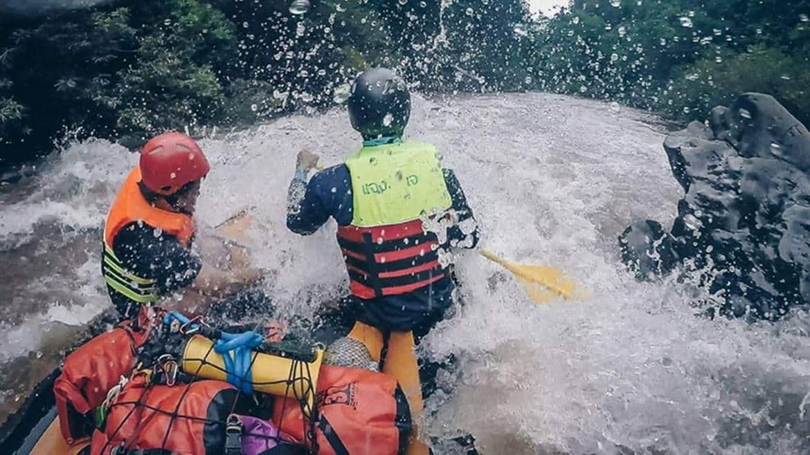
When you get there, the activity that you should never miss is ‘Rafting in Wa Stream’. That is the most popular activity among tourists who get there. The whole route for the boat paddling is about 19.2 kilometers. Now, that’s a long way. Make sure to manage all your personal business, like going to a toilet, before you start the boat trip.

The start point is Ban Nam Poo in Mae Charim County. The endpoint is Ban Had Rai in Wiang Sa County. The atmosphere will be relaxing. You will wear a life jacket and paddle a rubber boat with your friends or family. (Each boat can contain 8 people.) That will be fun. You guys will sail along a nice and quiet stream with green trees and mountains around. Ah, what lovely scenery!

")
")
")
However, if the route is too long for you, there is another route that takes only about 15 kilometers. The second route starts from the office of the national park to The Elephant Camp or Ban Had Rai. It takes 2-3 hours.

Besides the boat paddling, another interesting activity is to go hiking. There are some hiking routes around the national park. The first route is ‘Yod Pha Nho’, where you will walk up to the mountaintop, which is about 824 meters higher than the sea level, and explore the cave. It takes about 8 kilometers and 6 hours.
Another route starts from the office of the national park to the edge of Wa River. It takes only about 1 hour and 2 kilometers. It’s perfect for those who can get exhausted easily.
The third route starts from Ban Nam Pang to Ban Rom Klao. It takes about 8 kilometers. This route is perfect for you if you want to see little birds of different species, as there are lots of them on the way.

After finishing all the fun activities, you probably get sore. Let’s get to the restaurant in the national park and find something to eat. It’s open daily, from 8:30-16:30.
Mae Charim National Park Map
Address: Nam Pai, Mae Charim District, Nan 55170
52.7 kilometers from Nan Nakhon Airport.
48.7 kilometers from Nan Bus Terminal.
47.7 kilometers from Nan Province.
96.9 kilometers from Pua District.
110 kilometers from Bo Kluea District.
51.1 kilometers from Santi Suk District.
77.2 kilometers from Na Noi District.
98 kilometers from Na Muen District.
Tel: 095-720-2753, 080-679-9070 (during office hours only.)
Source: http://nantourism.go.th/travel-detail.php?id=29 / http://nantourism.go.th/travel-detail.php?id=23 / https://www.facebook.com/maecharim.nan/ / https://mychiangmaitour.com/mae_charim_national_park/